Walter F. George Lock and Dam by the Numbers: An 88-Foot Lift, a 12,128-Foot Dam and a 45,180-Acre Lake With 640 Miles of Shoreline
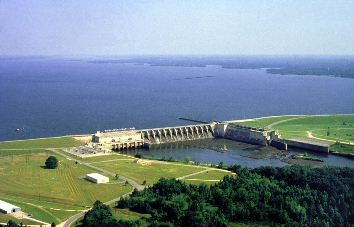
An aerial view of the Walter F. George Lock and Dam and the lake behind it on the Chattahoochee River. Photo: / Wikimedia Commons (public domain)
COLUMBUS, Ga. - Downstream from Columbus, the Chattahoochee River is stopped by one of the biggest structures on the Georgia-Alabama line: the Walter F. George Lock and Dam. The U.S. Army Corps of Engineers owns and operates the project, which includes a hydroelectric powerhouse, and the lake behind it has become one of the region's best-known fishing and camping destinations. The Corps' official data sheet gives a dam 12,128 feet long, a lock that lifts boats 88 feet and a lake of 45,180 acres at full summer level.
Alabamians know the lake as Lake Eufaula, while Georgians use the name of the dam. Both names point to the same water, which stretches about 85 miles north from the dam along the state line. The numbers below come from the Corps' Mobile District and are meant as a quick reference for boaters, anglers and anyone curious about the river that runs through Columbus.
The dam and lake by the numbers
| Measure | Figure |
|---|---|
| Dam length | 12,128 feet total (6,124 feet on the right bank, 6,004 feet on the left) |
| Spillway section | 708 feet |
| Dam height | 68 feet at its maximum |
| Lock chamber | 450 feet long, 82 feet wide |
| Lock lift | 88 feet |
| Full-pool elevation | 190 feet above sea level |
| Lake area at full level | 45,180 acres |
| Lake length | 85 miles |
| Shoreline | 640 miles at full pool |
| Powerhouse | 4 generators of 32,500 kilowatts each; 130,000 kilowatts installed |
| Drainage area at the dam | 7,460 square miles |
| Storage to full pool | 934,400 acre-feet |
An 88-foot lift
The lock is the most unusual feature. Boats entering from the river below are raised 88 feet inside a chamber 450 feet long and 82 feet wide to reach the lake above, according to the Corps' pertinent-data sheet. The dam itself stands 68 feet at its maximum, and its top is at 215 feet above sea level.
Because the lake sits at a full-pool elevation of 190 feet, the Corps manages the level through a conservation range. The minimum conservation pool is 184 feet, and the sheet lists 36,375 acres at that level compared with 45,180 acres at full pool. The difference between the two levels is a storage volume of 244,400 acre-feet.
Power from the Chattahoochee
The powerhouse has four generating units rated at 32,500 kilowatts each, for 130,000 kilowatts of installed capacity at the rated power factor, according to the Corps. The sheet lists 145,000 kilowatts at unity power factor, and some outside listings quote higher totals, so the Corps' own figure is used here. The dam sits on a drainage area of 7,460 square miles, and the Corps notes that 4,020 square miles of that lies between the dam and West Point Dam upstream.
The project was authorized by the Rivers and Harbors Act of 1944, according to the Corps' hydropower page, with construction beginning in 1957 and the project placed in service in 1963. Other references list work beginning as early as 1955, so the start date varies by source. Congress changed the project's name in 1958 from Fort Gaines Lock and Dam to honor Walter F. George, the Georgia senator who lived from 1878 to 1957.
Two names for one lake
Alabama's legislature passed a resolution on June 25, 1963, naming the reservoir Lake Eufaula, according to reference listings. The lake runs along the Alabama-Georgia state line, with Eufaula, Alabama, and Fort Gaines, Georgia, among nearby communities. The Corps reports a shoreline of 640 miles, although reference sources note that shoreline is not a well-defined measure.
Protected lands around the water include the Eufaula National Wildlife Refuge and Lakepoint State Park in Alabama, and Florence Marina and George T. Bagby state parks in Georgia. The Corps manages 13 day-use parks and four campgrounds on the lake, according to its recreation listing. Reference sources give an average depth of 15 to 18 feet and a maximum of about 100 feet, though that source is flagged as needing additional citations.
What flooding the lake cost
Filling the reservoir covered Native American historic and prehistoric sites, according to reference sources. The unincorporated community of Oketeyeconne, Georgia, which had a majority Native American population, was evacuated in the 1950s. The loss is part of the dam's history alongside its economic and recreational role.
Planning a visit
- Check lake levels, lock schedules and park hours with the Corps' Mobile District before traveling.
- Camping reservations for Corps campgrounds are handled through Recreation.gov.
- Georgia and Alabama fishing licenses apply depending on where you fish, so confirm which state's rules cover your spot.
- Visit the Corps' recreation pages for maps and seasonal closures.
Source: U.S. Army Corps of Engineers, Mobile District, Walter F. George pertinent data (water.sam.usace.army.mil); Corps hydropower and recreation listings

News organizations may republish this story with credit. See our guidelines.
Know someone who'd want to read this? Email it to a friend.
Plan your weekend with Columbus Times
Get This Weekend in Columbus every Thursday: the best local events, free things to do and family fun, plus each evening's local news. Free, and you can unsubscribe anytime.
By signing up you agree to get the Columbus Times email newsletter. Unsubscribe anytime with one click.


Comments
Be respectful. No personal attacks, hate speech, spam or anyone's private information. Every comment is reviewed before it appears. Comment rules
No comments yet. Be the first to share your thoughts.